



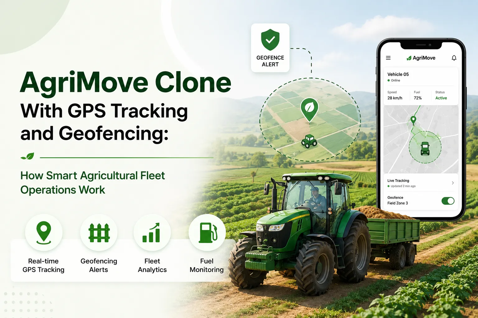
Key Takeaways
- An AgriMove clone turns farm movement into real-time operational visibility.
- GPS tracking shows tractors, harvesters, trucks, and field assets live.
- Geofencing automates zone entry, exit, delay, and restricted-area alerts.
- Offline sync keeps field operations working in low-connectivity areas.
- Admin dashboards connect equipment, users, alerts, reports, and maintenance.
Fleet Operation Signals
- Check live GPS, route history, stop duration, and idle time.
- Review geofence rules for fields, warehouses, and restricted zones.
- Track engine hours, fuel records, maintenance alerts, and equipment usage.
- Test offline logs, delayed sync, photo proof, and task confirmation.
- Verify role-based access for operators, supervisors, and admins.
Real Insights
- GPS gives visibility, while geofencing turns location into action.
- Agricultural fleets need field logic, not generic city-delivery tracking.
- Rural connectivity makes offline-first workflows essential.
- Maintenance and idle-time data can reduce avoidable operational delays.
- Miracuves builds AgriMove Clone apps with GPS, geofencing, and field-operation workflows.
Agriculture has always depended on movement. Tractors move between fields. Harvesters work across zones. Trucks carry produce to storage, mills, markets, or processing centers. Field supervisors coordinate workers, machines, fuel, maintenance, routes, and timing while conditions change on the ground.
That is why an AgriMove Clone GPS Tracking Geofencing is not just another map-based app. It is a smart agricultural fleet operations system that helps farm owners, agribusinesses, cooperatives, contractors, and agri-logistics teams know where their equipment is, whether it is working in the right zone, how long it stayed there, and when action is needed.
Public app store listings describe Agrimove as a field-user application for data mapping and management, built for users working with Corteva. An AgriMove clone can take that field-operations idea further by adding real-time fleet visibility, geofence alerts, engine-hour tracking, maintenance reminders, route history, fuel monitoring, offline sync, and role-based dashboards.
For founders, the opportunity is practical. Farmers and agri-business operators do not need software that only looks modern. They need a system that helps answer daily operational questions:
- Which tractor is working in Field A?
- Did the harvester enter the assigned crop zone?
- How long did the truck wait near the warehouse?
- Was equipment used after working hours?
- Which vehicle is idle, delayed, or off-route?
- Which machine needs maintenance based on engine hours?
- Which field team needs support right now?
Miracuves helps founders build white-label, source-code-owned app solutions that can be customized for smart agriculture, fleet tracking, logistics, and field operations. For an AgriMove-style platform, the goal is to turn location data into better agricultural decisions.
What Is an AgriMove Clone?
An AgriMove clone is a smart agriculture field-operations app inspired by the idea of mobile data mapping, field coordination, and agricultural activity management. Instead of limiting the product to basic mapping, a strong clone app can include GPS fleet tracking, geofencing, equipment monitoring, field activity logs, supervisor dashboards, alerts, reports, and farm logistics workflows.
The product can be designed for:
- Farm owners
- Agricultural contractors
- Custom hiring centers
- Cooperatives
- Seed and crop companies
- Harvesting teams
- Agri-logistics operators
- Equipment rental businesses
- Plantation companies
- Dairy and produce transport teams
- Rural supply-chain operators
Unlike general fleet management software, an agricultural fleet app must understand farm realities. Fields may be remote. Network coverage may be unstable. Machines may work slowly across irregular land boundaries. Equipment may be shared between multiple users. Contractors may need proof of work. Supervisors may need offline field logs. Admins may need reports by field, machine, driver, crop zone, or work order.
That is where GPS tracking and geofencing become valuable.
Read more- What Is an AgriMove-Like App and How Does an Agricultural Logistics Platform Work?
How GPS Tracking Works in an AgriMove Clone
GPS tracking allows the platform to show the real-time or near-real-time location of tractors, harvesters, threshers, trucks, sprayers, trailers, and other farm assets.
A basic system shows dots on a map. A smarter agricultural GPS tracking system connects location with operations.
It can show:
- Current vehicle location
- Movement direction
- Speed
- Route history
- Stop duration
- Idle time
- Assigned field
- Driver or operator
- Work order
- Engine status
- Fuel level, where hardware supports it
- Maintenance status
- Trip start and end points
- Field arrival and departure time
Geotab’s agriculture fleet software highlights similar use cases such as route planning, maintenance schedules, cellular or satellite fleet monitoring, and heavy machinery visibility. Razor Tracking also positions agriculture fleet tracking around geofencing, historical route playback, maintenance alerts, equipment usage, engine-hour tracking, and one-screen visibility.
For an AgriMove clone, GPS tracking becomes the base layer. It tells the platform where something is. The business value comes when that data is connected to farm tasks, geofences, alerts, reports, and decisions.
How Geofencing Works in Agricultural Fleet Operations
Geofencing creates virtual boundaries around real-world locations. In agriculture, those locations may include fields, crop zones, farm gates, storage yards, loading points, weighbridges, warehouses, irrigation zones, restricted areas, or delivery destinations.
When a vehicle or equipment asset enters, exits, or stays inside a geofence, the system can trigger a rule.
For example:
- A tractor enters Field 12 → mark the work order as started.
- A harvester exits the assigned zone → alert the supervisor.
- A truck stays at the warehouse for too long → flag loading delay.
- Equipment moves after working hours → send unauthorized-use alert.
- A vehicle reaches a collection center → notify the operations team.
- A sprayer enters a restricted zone → block task completion until reviewed.
Razor Tracking describes agriculture geofencing as a way to see time spent in points of interest during harvest or planting. Blackbox GPS lists geofencing, real-time tracking, fuel monitoring, engine and thresher working hours, area calculation, reports, and instant alerts as agriculture fleet management capabilities.
The key difference is this: GPS tells you where the equipment is. Geofencing tells you whether that movement is operationally correct.
Why Geofencing Matters More in Agriculture Than Generic Fleet Tracking
In normal fleet tracking, geofencing often means alerts around depots, customer locations, or restricted routes. In agriculture, geofencing has more operational depth because the boundary itself represents work.
A field is not just a location. It is a task zone.
A farm gate is not just a point on a map. It can mark entry, exit, security, and attendance.
A warehouse is not just a delivery app. It may represent loading time, waiting time, weighing, inventory handover, and dispatch.
That is why a smart AgriMove clone should allow flexible geofence creation for:
- Fields
- Crop blocks
- Harvest zones
- Irrigation areas
- Storage points
- Warehouses
- Market yards
- Processing centers
- Equipment parking areas
- Fuel stations
- Restricted land
- Contractor work zones
This makes the platform useful for daily operations instead of only asset tracking.
Core Features Every AgriMove Clone Should Include
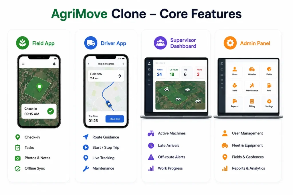
A strong AgriMove clone should have separate experiences for field users, drivers or operators, supervisors, and platform admins.
1. Field User App
The field user app should help workers and supervisors capture ground-level activity without complicated steps.
Important features include:
- Mobile login
- Assigned tasks
- Field map view
- GPS-enabled check-in
- Work start and end logs
- Offline data entry
- Photo upload
- Notes and issue reporting
- Geofence-based task confirmation
- Sync when internet returns
- Notifications and alerts
Offline support matters because agricultural work often happens in rural or low-connectivity areas.
2. Driver and Equipment Operator App
Drivers and machine operators need a simple app that helps them complete jobs, follow routes, and confirm activity.
Features can include:
- Assigned vehicle or machine
- Route guidance
- Field destination
- Trip start and stop
- Live tracking permission
- Geofence check-in and checkout
- Fuel entry
- Maintenance issue reporting
- Digital proof of work
- Safety alerts
- Supervisor chat or call option
The app should not overload operators with unnecessary screens. In agriculture, simple workflows often perform better than complex dashboards.
3. Supervisor Dashboard
The supervisor dashboard connects field reality with daily planning.
It can show:
- Active machines
- Vehicles inside each field
- Late arrivals
- Idle assets
- Off-route alerts
- Geofence entry and exit logs
- Work order status
- Harvest or transport progress
- Operator activity
- Issue reports
- Field-level productivity
This helps supervisors coordinate work without calling every driver or visiting every field physically.
4. Admin Panel
The admin panel is where the business controls the entire agricultural fleet system.
It should include:
- User management
- Role-based access
- Vehicle and equipment management
- Field and geofence setup
- Task and work order management
- Route history
- Alerts and notifications
- Maintenance schedules
- Fuel records
- Reports and analytics
- Subscription or billing logic if the app is commercial
- Data export
- Audit logs
- Settings and permissions
At Miracuves, the admin control layer is treated as a business foundation, not just a backend screen. For agricultural fleet operations, the admin panel decides whether the platform can scale across farms, contractors, equipment categories, and regions.
Read more- Why AgriTech Startups Choose an AgriMove Clone Over Custom Platform Development
AgriMove Clone Features and Business Value
| Feature | Business Value | Founder Impact |
|---|---|---|
| Live GPS tracking | Shows the current location of tractors, harvesters, trucks, and field teams. | Improves visibility and reduces manual follow-up calls. |
| Geofencing | Creates virtual boundaries around fields, depots, warehouses, and restricted areas. | Enables automated alerts, task validation, and field-level accountability. |
| Route history | Stores previous trips, stops, field visits, and movement paths. | Helps resolve disputes and review operational efficiency. |
| Engine-hour tracking | Measures machinery usage for maintenance and utilization planning. | Supports better equipment lifecycle management. |
| Maintenance alerts | Triggers service reminders based on time, mileage, or engine hours. | Reduces avoidable downtime during critical farm seasons. |
| Offline sync | Allows field users to continue working in low-network areas. | Makes the app practical for rural operations. |
| Admin dashboard | Centralizes users, equipment, fields, alerts, and reports. | Gives the platform operator control over operations and scale. |
Smart Agricultural Fleet Operations: How the Workflow Works
An AgriMove clone with GPS tracking and geofencing usually works through a connected workflow.
Step 1: Admin creates farms, fields, and zones
The platform admin or farm manager adds the farm layout, field boundaries, storage locations, warehouses, and restricted areas. These become geofences inside the system.
Step 2: Equipment and users are added
Tractors, harvesters, trucks, sprayers, trailers, drivers, supervisors, and field staff are added to the platform. Each user receives role-based access.
Step 3: Work orders are assigned
The supervisor assigns tasks such as harvesting, spraying, transport, ploughing, inspection, loading, or delivery.
Step 4: GPS tracking starts
The app or GPS hardware starts sending location updates. The dashboard shows active assets on the map.
Step 5: Geofence rules trigger events
When a machine enters or exits a field zone, the system records the event. If a vehicle leaves the assigned route or enters a restricted area, the platform sends alerts.
Step 6: Field activity is logged
Operators can mark task status, add notes, upload images, report issues, or confirm completion.
Step 7: Reports help improve decisions
Managers can review route history, field time, idle time, engine hours, fuel logs, task completion, and exceptions.
This creates a full operations loop: plan, assign, track, verify, report, and optimize.
Founder Decision Signals
Speed
If your target users need fleet visibility before the next crop or harvest season, a ready-made foundation can reduce development delays compared with building every module from zero.
Cost
If the app needs GPS, maps, alerts, offline sync, admin dashboards, and reporting, cost depends on integrations, device support, map usage, and custom workflows.
Scalability
If the platform must support multiple farms, contractors, equipment types, and regional teams, role-based access and structured admin control are essential.
Market Fit
If users already struggle with delayed reporting, unauthorized equipment usage, poor visibility, or manual field coordination, GPS and geofencing can create immediate operational value.
Use Cases of an AgriMove Clone With GPS and Geofencing
1. Tractor and Harvester Tracking
Farm managers can track tractors, harvesters, threshers, and sprayers across different fields. This helps them know which equipment is active, idle, delayed, or outside its assigned area.
Blackbox GPS highlights engine and thresher working-hour reports, harvested area calculation, real-time tracking, reporting dashboards, and alert notifications as agricultural fleet features.
2. Harvest Transport Coordination
During harvest, timing matters. Trucks may need to move between fields, weighing points, warehouses, processing centers, and market yards. GPS tracking helps supervisors coordinate pickups, reduce confusion, and check delays.
3. Contractor Accountability
Agricultural contractors often manage equipment across multiple client farms. Geofence-based activity logs can help prove that a machine reached the assigned location and spent time inside the correct field.
4. Equipment Rental and Custom Hiring
Agricultural machinery rental platforms can use GPS and geofencing to monitor whether equipment is being used within approved areas and time windows. India’s FARMS app, for example, is designed to facilitate farm machinery hiring and sale or purchase through Custom Hiring Centres, Farm Machinery Banks, and Hi-tech Hubs.
5. Fuel and Idle-Time Monitoring
Fuel leakage, excessive idling, and unnecessary trips can increase operational costs. A smart fleet app can combine GPS movement, engine status, and fuel records to highlight waste patterns.
6. Maintenance Planning
Equipment breakdown during planting or harvest can create serious delays. Maintenance alerts based on engine hours, mileage, or calendar schedules help managers act before failure happens. Geotab and Razor Tracking both highlight maintenance monitoring as part of agriculture fleet management.
7. Field Staff Attendance and Task Verification
Field teams can check in from specific zones, and supervisors can verify whether the worker or equipment was actually present in the assigned area.
GPS Tracking vs Geofencing in an AgriMove Clone
| Capability | GPS Tracking | Geofencing |
|---|---|---|
| Main purpose | Shows current or historical location | Detects movement against virtual boundaries |
| Best for | Live visibility and route playback | Zone-based alerts and task verification |
| Example | “Where is the harvester now?” | “Did the harvester enter Field 7?” |
| Business value | Reduces uncertainty | Improves accountability |
| Operational trigger | Location update | Entry, exit, dwell time, or restricted-zone event |
| Founder impact | Core tracking feature | Higher-value workflow automation feature |
A smart AgriMove clone needs both. GPS provides visibility. Geofencing converts visibility into action.
Security and Data Control in Agriculture GPS Tracking Apps
Location data is sensitive. An agricultural fleet app may track vehicles, workers, machinery, routes, warehouses, and field boundaries. That means security should be built into the product foundation.
Important security layers include:
- Encrypted data transfer
- Role-based access control
- Admin permission settings
- Activity logs
- Secure API integration
- Device authentication
- User verification
- Location access permissions
- Data export controls
- Audit trails
- Alert history
- Privacy-conscious data handling
The public Google Play listing for Agrimove notes that the app may collect location data and that data is encrypted in transit. For a clone-style platform, the exact security architecture depends on the app’s operating model, integrations, hosting environment, and target market.
Founders should avoid treating GPS data as a casual feature. It can reveal business movement, operational behavior, field productivity, and asset locations. A strong platform should make location tracking transparent, permission-based, and admin-controlled.
Technology Stack for an AgriMove Clone
The technology stack depends on the product scope, but a practical AgriMove clone usually includes mobile apps, a web dashboard, backend APIs, maps, tracking services, cloud infrastructure, notification systems, and data storage.
A possible stack may include:
| Layer | Practical Options | Purpose |
| Mobile app | Flutter or React Native | Cross-platform field, driver, and supervisor apps |
| Web dashboard | React, Next.js, or Angular | Admin and operations control panel |
| Backend | Node.js, Laravel, Django, or similar | APIs, users, tasks, tracking, alerts, reports |
| Database | PostgreSQL, MySQL, MongoDB, or Firebase | Store users, vehicles, geofences, trips, logs |
| Real-time layer | WebSockets, MQTT, Firebase, or event streams | Live location updates and alerts |
| Maps | Google Maps, Mapbox, OpenStreetMap-based services | Field maps, routes, zones, geofences |
| Notifications | FCM, APNs, SMS, WhatsApp, email | Alerts for entry, exit, delay, maintenance |
| Cloud | AWS, Google Cloud, Azure, or private cloud | Hosting, scaling, storage, monitoring |
| Analytics | Custom reporting dashboards | Fleet utilization, idle time, route history |
Final stack selection should depend on map usage volume, tracking frequency, hardware integration, rural network conditions, offline requirements, and reporting complexity.
Monetization Models for an AgriMove Clone
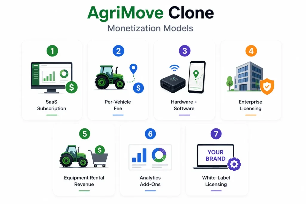
An AgriMove clone can be monetized in several ways depending on the target customer.
1. SaaS Subscription
Charge farm owners, contractors, or agribusinesses monthly or annually for access to the platform.
Possible pricing logic:
- Number of vehicles
- Number of users
- Number of farms
- Number of geofences
- Tracking frequency
- Report depth
- Storage duration
- Support level
2. Per-Vehicle Tracking Fee
This model works well for fleet-heavy businesses. The customer pays based on the number of tracked vehicles, equipment units, or assets.
3. Hardware + Software Bundle
If the platform uses GPS devices, IoT sensors, or telematics hardware, the business can sell or lease devices along with software access.
4. Enterprise Licensing
Large agribusinesses, plantations, cooperatives, OEMs, and logistics operators may need custom dashboards, integrations, data controls, onboarding, and service-level commitments.
5. Equipment Rental Marketplace Revenue
If the app includes machinery hiring, the platform can earn through commissions, booking fees, subscriptions, or featured listings.
6. Analytics and Reporting Add-Ons
Premium reports can include utilization trends, idle-time analysis, route efficiency, field-time reports, maintenance history, and contractor performance.
7. White-Label Licensing
Agri-tech companies, equipment dealers, and logistics operators may want their own branded version of the platform. A white-label model can create B2B licensing revenue.
AgriMove Clone Development Cost: What Affects Pricing?
The final cost of an AgriMove clone depends on features, integrations, map services, hardware support, tracking frequency, reporting depth, app platforms, and launch scope.
Key cost factors include:
- Android app only vs Android, iOS, and web
- GPS tracking frequency
- Geofencing complexity
- Offline sync
- Number of user roles
- Hardware or telematics integration
- Map provider and API usage
- Real-time alerts
- Admin dashboard depth
- Reporting and analytics
- Fuel and engine-hour monitoring
- Payment or rental marketplace features
- Cloud infrastructure
- Security requirements
- Custom branding
- Source-code handoff
Miracuves’ ready-made approach can reduce development time because the foundation already includes core app flows, admin control, and essential modules. Final pricing should be confirmed based on selected features, integrations, branding, and customization requirements. This follows Miracuves’ pricing rule to avoid invented costs and confirm scope-based pricing.
Read more- Best Marketing Strategies to Grow an AgriMove Clone Agricultural Logistics Platform
Ready-Made vs Custom AgriMove Clone Development
| Build Approach | Best For | Strength | Tradeoff |
| Ready-made white-label foundation | Founders who want faster market validation | Faster launch, lower starting complexity, existing app modules | May need customization for farm-specific workflows |
| Custom development | Enterprise agribusinesses with unique operations | Fully tailored architecture and workflows | Higher time, planning, and cost requirements |
| Hybrid approach | Founders who want speed plus custom field logic | Start with a foundation and customize key modules | Requires clear scope control |
For most founders, the best path is not to build every screen from zero. It is to start with a proven fleet, maps, admin, and user-management foundation, then customize the agricultural workflows that matter most.
Mistakes Founders Should Avoid
Building only a map view
Agricultural users need workflows, alerts, field zones, reports, and task validation. A map without operational logic has limited business value.
Ignoring rural connectivity
Many field operations happen in areas with unstable network coverage. Offline data capture and sync should be planned early.
Using generic fleet logic for farm equipment
Tractors, harvesters, sprayers, and trucks do not operate like city delivery vehicles. Agricultural workflows need field boundaries, engine hours, slow movement handling, and seasonal reporting.
Skipping admin control
Without a strong admin dashboard, the platform operator cannot manage vehicles, users, geofences, alerts, reports, or permissions at scale.
How Miracuves Can Help Build an AgriMove Clone
Miracuves helps founders, startups, agencies, and businesses launch ready-made, white-label, source-code-owned clone app solutions and custom app development services. The Miracuves solution approach focuses on faster launch, admin dashboards, monetization-ready platforms, custom branding, source-code ownership, and scalable backend foundations.
For an AgriMove clone, Miracuves can help shape the product around:
- Field user app
- Driver or operator app
- Supervisor dashboard
- Admin panel
- GPS tracking
- Geofence creation
- Route history
- Equipment management
- Offline sync
- Alerts and notifications
- Maintenance tracking
- Reports and analytics
- Role-based access
- White-label branding
- Source-code ownership
Founders can also explore Miracuves’custom mobile app development services, web app development services, Firebase app development services, and ready-made clone app solutions for related launch paths.
Final Thoughts: Smart Agricultural Fleet Apps Turn Field Movement Into Better Decisions
An AgriMove clone with GPS tracking and geofencing is valuable because agriculture is operationally complex. Machines move across fields. Drivers wait at warehouses. Equipment may be shared between contractors. Supervisors need proof of work. Farm owners need better visibility. Seasonal delays can affect productivity, cost, and delivery timing.
The stronger platform is not just a tracking screen. It is a connected field-operations system with GPS, geofencing, route history, offline sync, engine-hour tracking, maintenance alerts, reports, and admin control.
For founders, the opportunity is to build a product that helps agricultural businesses reduce uncertainty, improve equipment utilization, and coordinate smarter field operations. Miracuves can help launch that idea faster with a white-label, source-code-owned app foundation that can be customized for farm fleet operations, agri-logistics, equipment rental, or enterprise agribusiness workflows.
FAQs
1. What is an AgriMove clone?
An AgriMove clone is a smart agriculture field-operations app inspired by mobile data mapping and agricultural activity management. It can include GPS tracking, geofencing, field mapping, equipment monitoring, task management, alerts, and admin dashboards.
2. How does GPS tracking help agricultural fleet operations?
GPS tracking helps farm owners and supervisors monitor the live location of tractors, harvesters, trucks, sprayers, and other equipment. It improves visibility, reduces manual follow-ups, and supports better field coordination.
3. What is geofencing in an agriculture fleet app?
Geofencing creates virtual boundaries around fields, warehouses, farm gates, crop zones, restricted areas, or delivery points. The app can trigger alerts when equipment enters, exits, or stays inside a specific zone.
4. Can an AgriMove clone work in rural areas?
Yes, but the app should be designed with rural conditions in mind. Offline sync, low-bandwidth workflows, local data storage, GPS-device support, and delayed upload handling can make the platform more practical for field use.
5. What features should an AgriMove clone include?
Important features include live GPS tracking, geofencing, field mapping, route history, offline sync, task assignment, equipment management, engine-hour tracking, maintenance alerts, fuel records, reports, and admin control.
6. How can an AgriMove clone make money?
An AgriMove clone can earn revenue through SaaS subscriptions, per-vehicle tracking fees, hardware-plus-software bundles, enterprise licensing, equipment rental marketplace commissions, analytics add-ons, and white-label licensing.
7. How much does it cost to build an AgriMove clone?
The cost depends on features, platforms, map integrations, GPS hardware, tracking frequency, offline sync, admin dashboard depth, reporting, and customization. Founders should request a scope-based quote instead of relying on generic pricing.
8. Can Miracuves build an AgriMove clone with GPS tracking and geofencing?
Yes. Miracuves can help founders build a white-label AgriMove-style platform with field user apps, GPS tracking, geofencing, admin dashboards, alerts, reporting, and source-code ownership.